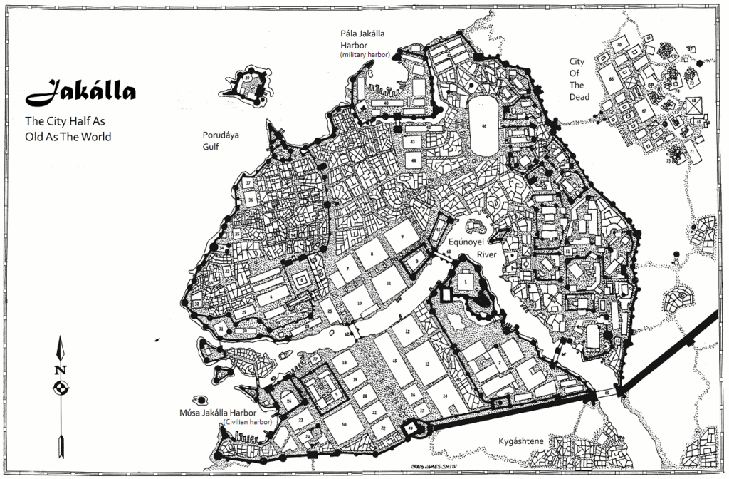
One of the interesting aspects of Empire of the Petal Throne is that it includes the first city map for a roleplaying game, the map of the city of Jakálla. (The first fully-detailed city setting, The City-State of the Invincible Overlord, was published by Judges Guild in 1976, a year after Empire of the Petal Throne.)
The map of the city of Jakálla was impressive, both then and now. Full color, it included nearly 80 different locations, some of which were straightforward, like “Armoury of Bushétra the Smith”, and some of which were intentionally mysterious, such as the “Pyramid Temple of the Ancient Unnamed One (not in use)”. There was more than enough there for referees to use in developing their Tékumel campaigns, and presented something of a challenge – lots of nonplayer characters to detail, plots to develop, and underworld levels to draw and populate. Fortunately, there was also a fair bit of detail in the rulebook about the setting to help with those tasks. But some things were not fully detailed or evident, even with all that, and so Prof. Barker got a lot of questions in fan mail about the city and how it worked. Here are a few of them:
- What is the scale of the map? There is no legend for the map itself, so the distance across each hex was left undefined. Further, Prof. Barker admitted that he was no urban geographer; his early estimates of 50 yards/meters to a hex were guesstimates, at best. As time went on, we discovered that Jakálla is an ancient city, with a population of over a million (we find this out later from The Tékumel Sourcebook). Later discussions concluded that the scale was probably 2-3x that, so 100-150 yards/meters is not unlikely – but might be more.
- Where do the newly-generated player characters arrive, in the “Fresh Off the Boat” beginning scenario? The answer is implied by the map: Pála Jakálla harbor is the military harbor – fortified, with a water channel surrounding it, and barracks and other military installations nearby. By contrast, Músa Jakálla harbor is the trade harbor – easy access to the Sákbe-road, at the mouth of the Eqúnoyel River, showing piers, wharves, and docks further upstream.
- In the rulebook it says, “Players who do attempt to enter Jakálla alone at this stage run the risk of making errors in speaking Tsolyáni or in the intricate rules of Imperial etiquette” – what does that mean for gameplay? (I don’t want to get impaled!) There are two different answers for this: unlike D&D, where adventurers were assumed to be on the frontier, pushing back against the forces of Chaos, adventurers in Tékumel were assumed to be from Barbarian Lands and have arrived in the heart of Civilization. So there is a real issue of in-setting social control, which gets reinforced elsewhere in the 1975 rules.
For gameplay, it is important to note the phrase “enter Jakálla alone” – I want to stress that word “alone.” Sec. 1110 in the rulebook provides for patrons and potential missions, but it is also possible to provide adventurers with nonplayer character guides – spend a few Káitars and gain a friend – who will guide you from the docks to the Tower of the Red Dome, or another hostel. That’s how to avoid committing any faux pas. - Where do people socialize and meet others? Well, there are no taverns or bars in Tékumel, so aside from casual encounters at food stalls, merchants in the marketplaces, meeting like minded worshippers in the courtyards of temples, visits to the four Palaces of the Empire for various kinds of employment, the one place where Tsolyáni of different social statuses come together to rub elbows is at the Hirilákte Arena. Supporting different gladiators, placing bets, comparing notes – these are all opportunities to meet friends, possible patrons or helpers of one sort or another.
There is more to say about Jakálla, including answering questions like: where are the marketplaces of the city? How does one get into the Underworld? How do you get onto the Sákbe-road? What happens if you run out of money? What about the City of the Dead? Who lives in the nearby villages? I will attempt to answer some of those questions, but for today, I will leave you with a rough sketch of how the city is divided up and what goes where.
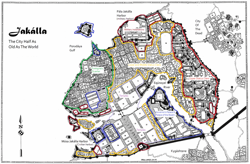
The thing which I found most surprising here is that there are no taverns/bars/etc.. I can see that the Tékumel default would be to go back to the clanhouse or buy from a street seller, and that cross-hierarchy meeting places would be problematic and frowned upon. But it still seems peculiar.
I like your zoning. It does have the look of deliberate decision to it, but that might be a not-really-expected consequence of the hierarchic nature of the society.
The expectation that there would be bars or taverns or the like is a fairly Western one, I should think. It is worth remembering that Prof. Barker was, indeed, profoundly influenced by Indian and Arabic as well as Meso-American cultures and societies, and that shaped this aspect of Tekumel. The “deliberate decision” aspect of zoning has an in-setting explanation: the custom of Ditlana; every city is supposed to be torn down and rebuilt according to a new plan every 500 years – not too surprisingly, this is not always observed with any precision, either in time or in planning.
I was always intrigued by the city of the dead.
The City of the Dead? That’s where the fun takes place – let’s get this party started! 😉